
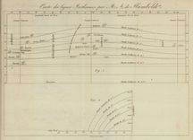
Carte des Lignes Isotherms par M. A. de Humboldt
Humboldt devised this chart to represent lines of equal temperature, which enabled observers to think about the relationship between temperature patterns and other phenomena.
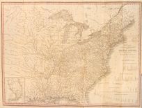
Here you can learn how medical men turned to maps in an urgent quest to solve the deadly mysteries of yellow fever and cholera. Their groundbreaking work was closely related to the race to map the environment in a nation that was rapidly expanding westward.
Humboldt devised this chart to represent lines of equal temperature, which enabled observers to think about the relationship between temperature patterns and other phenomena.
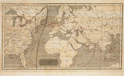
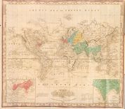
Woodbridge devised this world map to represent not topographic detail, but social, cultural, and political geography.
This chart adopted Alexander von Humboldt’s innovation of isothermal lines in order to enable students to investigate the relationship between temperature and agricultural output.
The international cholera epidemic of 1832 encouraged Brigham, and many others, to adopt maps to analyze the source and path of the disease.
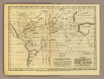
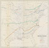
The Philadelphia mapmaker Henry Tanner adapted his existing map of the U.S. to trace the cholera epidemic of 1832. Notice his use of red ink to identify the cities of the outbreak.
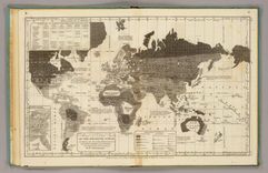
Frustrated by what he considered the flawed and misleading maps of cholera, Henry Tanner designed this world map to identify the geographic and chronological phases of the epidemic.
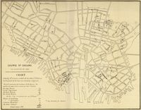
This is one of many examples of a map designed for etiological purposes, in this case to locate the source of the city’s 1849 cholera epidemic.
Baltimore’s city physician Thomas Buckler designed this map to study the pattern of cholera in 1849, particularly as it related to the city’s water supply and to the outbreak of fever.
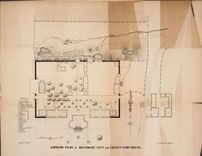
Buckler adopted a cartographic approach to the cholera outbreak of 1849 by mapping the pattern of disease in the city as well as within the alms house.
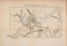
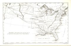
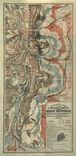
Barton compiled this complex map to locate the origin of the yellow fever outbreak of 1853, even noting the arrival of ships in the city port.
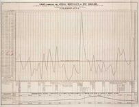
Barton designed this longitudinal chart to study the relationship between yellow fever and other aspects of city life, including weather and seasonal changes.
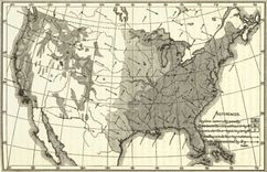
Forry, a physician, made the first map of climate patterns at the request of the Surgeon General, to study the relationship between geography and disease.
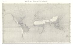
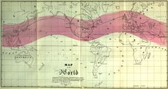
Guyot adapted this map to illustrate the dramatic differences of rainfall around the world, collapsing extensive data onto a single image.
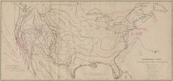
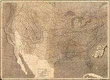
This is one of five charts of temperature designed by Lorin Blodget, the first made in the United States and derived from decades of research collected by the Smithsonian Institution.
This annual chart of temperature, designed and compiled by Lorin Blodget, was one of the earliest work by the famed lithographer Julius Bien.
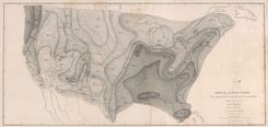
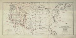
Blodget published several maps of seasonal and annual rainfall, the result of decades of observations collected by the Smithsonian, the Army, and other federal agencies.
Notice that Joseph Henry uses this map to integrate several different aspects of the environment, including rainfall, woodland, and prevailing winds.
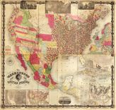
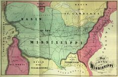
Maury compiled this massive wall map to showcase new thematic maps on the eve of the Civil War, which appear along the lower edge of the map.
The “Washington Map” was continually updated through the 1860s to reflect the availability of new information, as with the Eighth Census of 1860.
Blodget published several maps of seasonal and annual rainfall, the result of decades of observations collected by the Smithsonian, the Army, and other federal agencies.
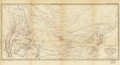
The use of lines to represent average temperatures spread quickly in the nineteenth century. Stevens’ chart is designed to promote a northern transcontinental railroad route in the 1850s.
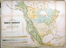
Gilpin designed this to shift the nation’s center of gravity westward toward the neglected interior, just as the nation acquired new territories in 1848
Gilpin emphasized geographical relationships to showcase the “great basin” of the interior, which he predicted would soon become the economic, political, and demographic center of the nation.
Gilpin adopted Humboldt’s lines to “demonstrate” that the U.S. was destined for economic and political supremacy.
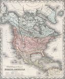
Disturnell was one of many to adopt Humboldt’s isotherm lines, here used alongside other measures to study “civilization” in North America.
By the 1860s mapping agriculture had become commonplace, and spread quickly in the twentieth century.
Denison designed several maps to promote migration to the Front Range, including this one touting the health benefits of Colorado’s climate.