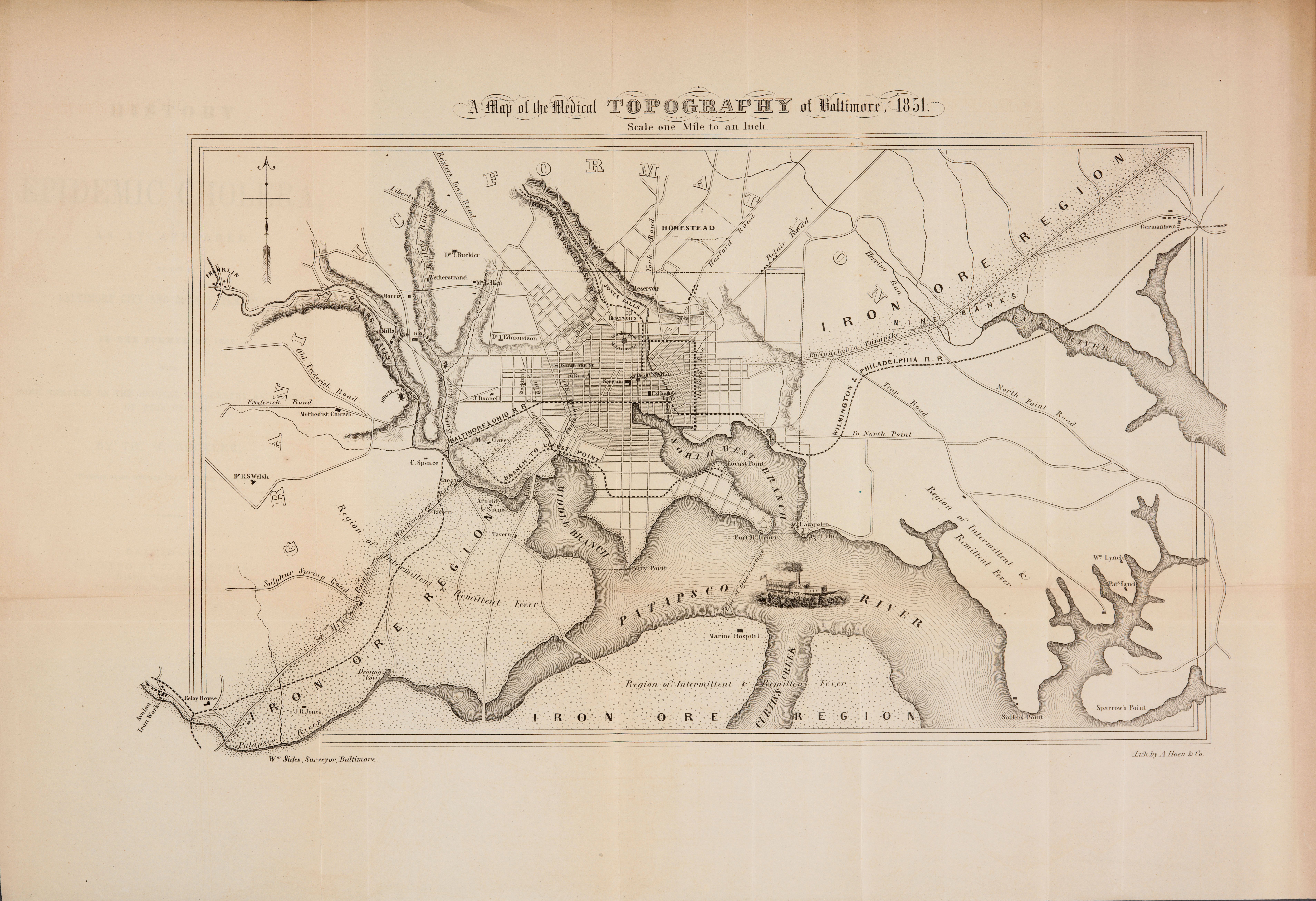
| Title | Map of the Medical Topography of Baltimore
|
| Alternate Title | Map of the Medical Topography of Baltimore
|
| Creator | Sides, William
|
| Type of Resource | cartographic
|
| Date Created | 1851
|
| Digital Origin | reformatted digital
|
| Topics | Cholera | Epidemics | Epidemiology
|
| Places | Baltimore (Md.)
|
| Dates | 1849 | 1851
|
| Subject Genre | Statistical maps
|
| Handle | http://hdl.handle.net/10176/codu:57809
|
| Rights Statement | Digitized by the Huntington Library, Art Collections and Botanical Gardens. Mounted here by permission for scholarly, educational, artistic, cultural, or scientific purposes. The user is responsible for all copyright, privacy and publicity rights compliance.
|
| Language | English
|
| Extent | 1 online resource (map) : TIFF file.
|
| Physical Note | Raster | Original Sheet(s): 31 x 46 cm.
|
| Scale | 1:63,360
|
| Notes | » Website description: Baltimore’s city physician Thomas Buckler designed this map to study the pattern of cholera in 1849, particularly as it related to the city’s water supply and to the outbreak of fever. | » Wm. Sides, Surveyor; Lith. by A. Hoen & Co. | » Relief shown by hachures. | » Identifies iron ore regions, railroad lines, regions of intermittent & remittent fever and outlying roads. | » Classification: G3844 .B2 1851.S5 Classification Scheme: lcc. | » Host Creator: Th. H. Buckler. Host extent: 45, [1] p., [5] folded leaves of plates : 2 maps ; 22 cm | » Alternate title from Website.
|
| Local Identifiers | Buckler_Map.tif | nationID: 3.08 | nationIDchrono: 2.08 | nationIDcreator: 1.74 | (DLC)unk82061343 | (OCoLC)741751948 | (OCoLC)14830353 (Host) | (OCoLC)793620824 (Host) | (CSsH)487572 (Host)
|