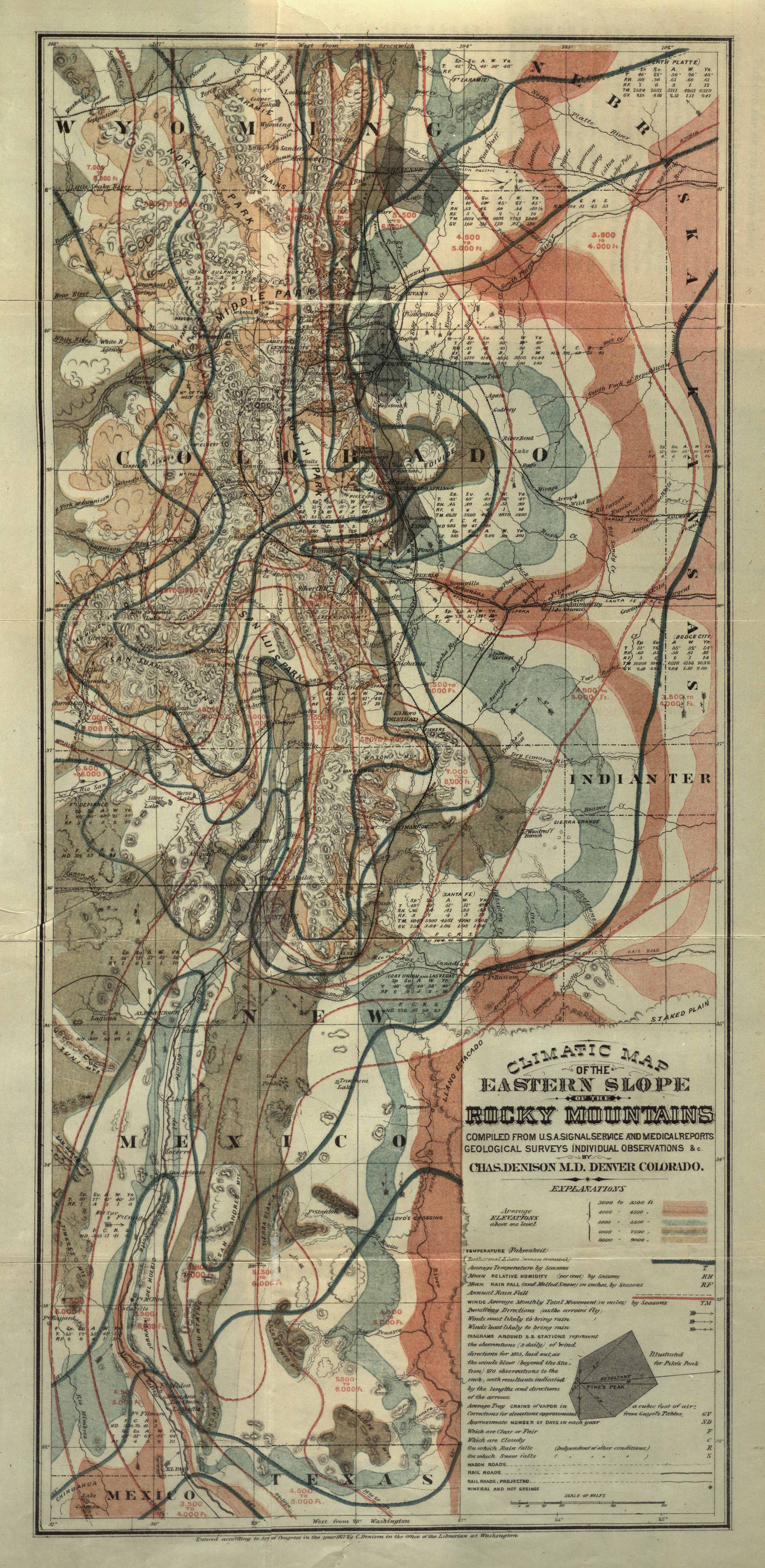
| Title | Climatic Map of the Eastern Slope of the Rocky Mountains
|
| Alternate Title | Climatic Map of the Eastern Slope of the Rocky Mountains
|
| Creator | Denison, Charles, 1845-1909
|
| Type of Resource | cartographic
|
| Date Created | 1877
|
| Digital Origin | reformatted digital
|
| Topics | Medical climatology | Climatotherapy
|
| Places | Wyoming | Colorado | New Mexico | Texas
|
| Dates | Nineteenth century
|
| Subject Genre | Statistical maps | Meteorological charts
|
| Handle | http://hdl.handle.net/10176/codu:58001
|
| Rights Statement | Made available by the University of Denver Penrose Library solely for research and educational purposes. The user is responsible for all copyright, privacy and publicity rights compliance.
|
| Publisher | Riverside Press
|
| Language | English
|
| Extent | 1 online resource (map) : TIFF file, col.
|
| Physical Note | Raster | Original Sheet(s): 54 x 25 cm.
|
| Scale | Scale not given.
|
| Coordinates | (W 108°--W 102°/N 42°--N 32°)
|
| Notes | » Website description: Denison designed several maps to promote migration to the Front Range, including this one touting the health benefits of Colorado’s climate. | » Scale bar in map image. | » Prime meridians: Washington and Greenwich. | » Relief shown by hachures, tints and contours. | » Contour interval: 500 feet. | » Depicts road and rail transportation routes, isothermal lines, mean temperatures, relative humidity, precipitation and prevailing winds in portions of Wyoming, Colorado, New Mexico and Texas. | » Host/Source Creator: Denison, Charles, 1845-1909. Host Type of Resource: text. Host Extent: xii, 192 p. : fold. map, fold. chart ; 21 cm. | » Alternate title from Website.
|
| Local Identifiers | Eastern_Slope_Climatic_Map.tif | nationID: 3.25 | nationIDchrono: 4.34 | nationIDcreator: 1.18 | (DLC)rc 01001013 (Host) | (OC0LC)35687142 (Host)
|