| Title | Course of Cholera in Boston in 1849
|
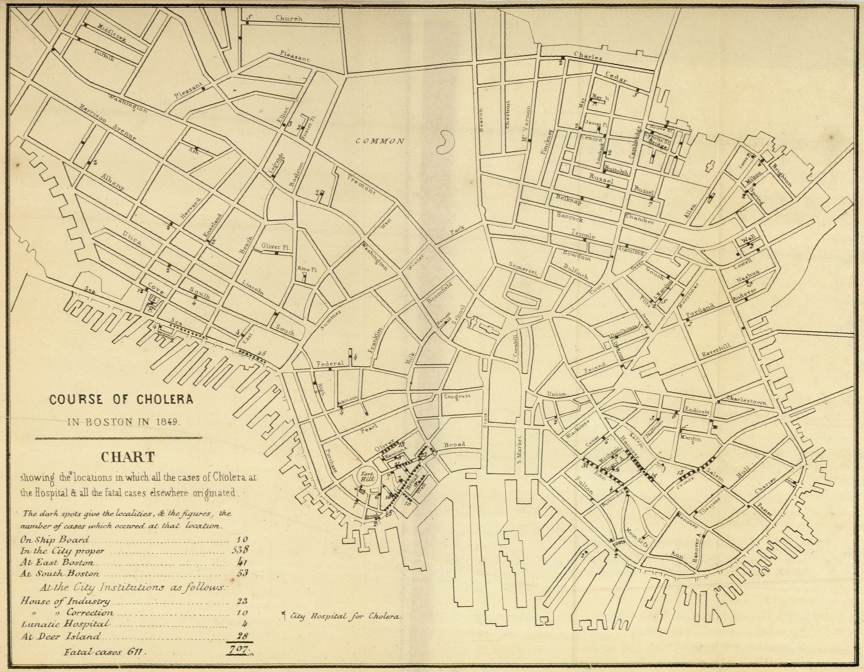
| Alternate Title | Chart Showing the locations in which all the cases of Cholera at the Hospital and all the fatal cases elsewhere originated | Report on cholera in Boston, 1849 | Course of Cholera in Boston in 1849
|
| Creator | Williams, Henry W. (Henry Willard), 1821-1895
|
| Type of Resource | cartographic
|
| Date Created | 1849
|
| Digital Origin | reformatted digital
|
| Topics | Cholera | Epidemiology | Epidemics
|
| Dates | 1849
|
| Subject Genre | Statistical maps | Medical statistics
|
| Handle | http://hdl.handle.net/10176/codu:57044
|
| Rights Statement | Digitized and made available by the University of Denver Penrose Library solely for research and educational purposes. The user is responsible for all copyright, privacy and publicity rights compliance.
|
| Publisher | J.H. Eastburn
|
| Language | English
|
| Extent | 1 online resource (map) : TIFF file.
|
| Physical Note | Raster | Original Sheet(s): 22 x 26 cm.
|
| Scale | [1:9930]
|
| Notes | » Website description: This is one of many examples of a map designed for etiological purposes, in this case to locate the source of the city’s 1849 cholera epidemic. | » “... Dr. [Henry W.] Williams has supplied the topographical statistics ...”--Host, p. 20. | » Host Type of Resource: text. Host Extent: 180, [2] p. including illus., tables : folded map ; 24 cm. Host Notes: Report signed by Henry G. Clark, superintendent. Date on cover: 1850. | » Last alternate title from Website.
|
| Local Identifiers | nationID: 3.07 | nationIDchrono: 2.07 | nationIDcreator: 1.100 | (DLC) 34023586 (Host) | (OCoLC)3338359 (Host)
|