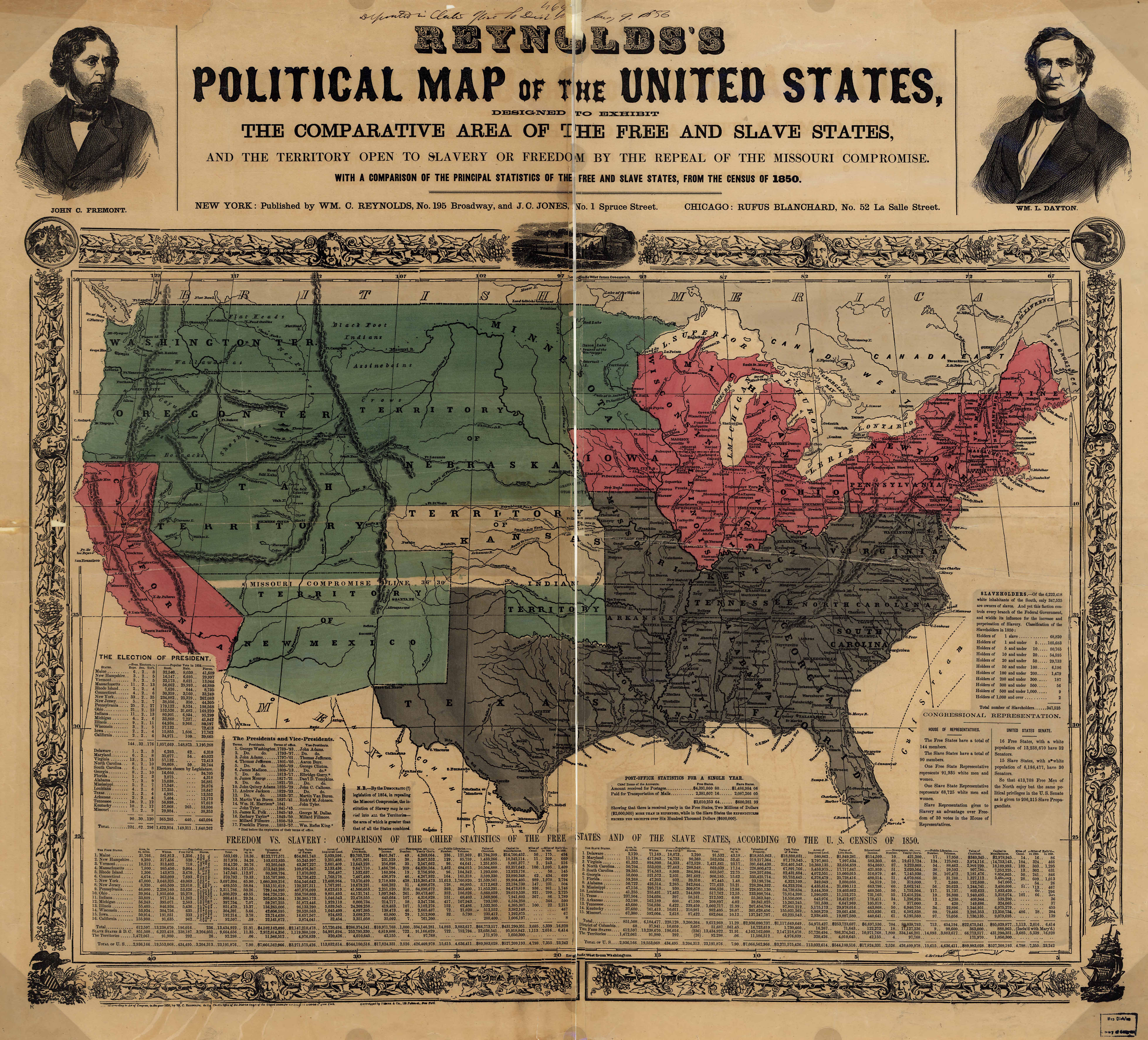
| Title | Reynolds's Political Map of the United States
|
| Alternate Title | Political Map of the United States | Reynolds's Political Map of the United States
|
| Creator | Reynolds, William C. | Jones, J. C.
|
| Type of Resource | cartographic
|
| Date Created | 1856
|
| Digital Origin | reformatted digital
|
| Topics | Slavery
|
| Places | United States
|
| Dates | Nineteenth century
|
| Subject Genre | Statistical maps
|
| Handle | http://hdl.handle.net/10176/codu:57073
|
| Rights Statement | The maps in the Map Collections materials were either published prior to 1922, produced by the United States government, or both (see catalogue records that accompany each map for information regarding date of publication and source). The Library of Congress is providing access to these materials for educational and research purposes and is not aware of any U.S. copyright protection (see Title 17 of the United States Code) or any other restrictions in the Map Collection materials. Note that the written permission of the copyright owners and/or other rights holders (such as publicity and/or privacy rights) is required for distribution, reproduction, or other use of protected items beyond that allowed by fair use or other statutory exemptions. Responsibility for making an independent legal assessment of an item and securing any necessary permissions ultimately rests with persons desiring to use the item.
|
| Publisher | W.C. Reynolds and J.C. Jones
|
| Language | English
|
| Extent | 1 online resource (map) : TIFF file. col.
|
| Physical Note | Raster | Original Sheet(s): 47 x 69 cm.
|
| Scale | 1:7,200,000
|
| Coordinates | (W 125°--W 67°/N 50°--N 25°)
|
| Notes | » Website description: One of several maps made to promote Republican John Fremont’s campaign for president in 1856. Note that Kansas is highlighted, the center of violent conflict over slavery. | » Ports. of J.C. Fremont and W.L. Dayton in border. | » Relief shown by hachures. | » Includes statistics from the 1850 census and ill. | » Classification: G3701.E9 1856 .R4 Classification Scheme: lcc. | » Last alternate title from Website.
|
| Local Identifiers | Reynolds_s_political_Map_of_the_United_States.tif | nationID: 4.06 | nationIDchrono: 2.21 | nationIDcreator: 1.72 | (DLC) 2003627003 | (OCoLC)21810705
|