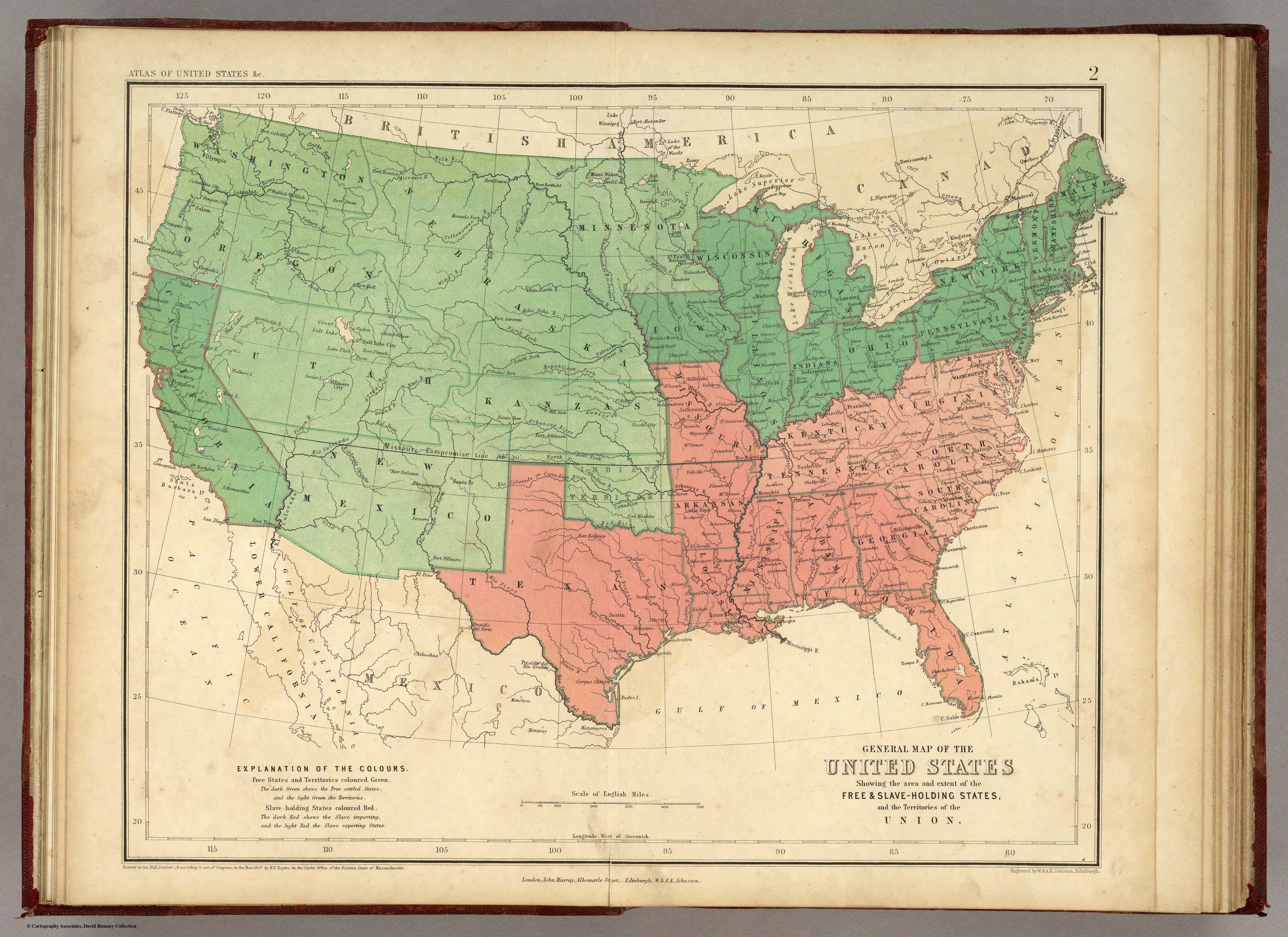
| Title | General Map of the United States
|
| Alternate Title | Boundary of the seceding states | General Map of the United States
|
| Creator | Johnston, Alexander Keith, 1804-1871 | Rogers, Henry D. (Henry Darwin), 1808-1866
|
| Type of Resource | cartographic
|
| Date Created | 1857
|
| Digital Origin | reformatted digital
|
| Topics | Slavery | Slave trade
|
| Places | United States | Canada | Mexico
|
| Dates | Nineteenth century
|
| Subject Genre | Thematic maps
|
| Handle | http://hdl.handle.net/10176/codu:55749
|
| Rights Statement | The maps in the Map Collections materials were either published prior to 1922, produced by the United States government, or both (see catalogue records that accompany each map for information regarding date of publication and source). The Library of Congress is providing access to these materials for educational and research purposes and is not aware of any U.S. copyright protection (see Title 17 of the United States Code) or any other restrictions in the Map Collection materials. Note that the written permission of the copyright owners and/or other rights holders (such as publicity and/or privacy rights) is required for distribution, reproduction, or other use of protected items beyond that allowed by fair use or other statutory exemptions. Responsibility for making an independent legal assessment of an item and securing any necessary permissions ultimately rests with persons desiring to use the item.
|
| Publisher | London : E. Stanford ; Edinburgh : W. & A.K. Johnston
|
| Language | English
|
| Extent | 1 online resource (map) : JPEG file, col.
|
| Physical Note | Raster | Original Sheet(s): 1 map : hand col. ; 31 x 42 cm., folded to 9 x 12 cm.
|
| Scale | 1:10,500,000
|
| Coordinates | (W 125°--W 65°/N 50°--N 25°)
|
| Notes | » Website description: Here Johnston distinguished between states important and exporting slaves in order to convey areas of growth and decline in the south. | » "Entered in Sta. Hall, London - & according to act of Congress in the year 1857 by H.D. Rogers, in the Clerks Office of the District Court of Massachusetts." | » Includes list of "Population in 1856" for free and slave states. | » Engraved by W. & A.K. Johnston, Edinburgh. | » Last alternate title from Website.
|
| Local Identifiers | Johnston_Map_of_the_United_States.tif | nationID: 4.08 | nationIDchrono: 2.23 | nationIDcreator: 1.48 | (DLC) 97682063 | (OCoLC)48617473
|