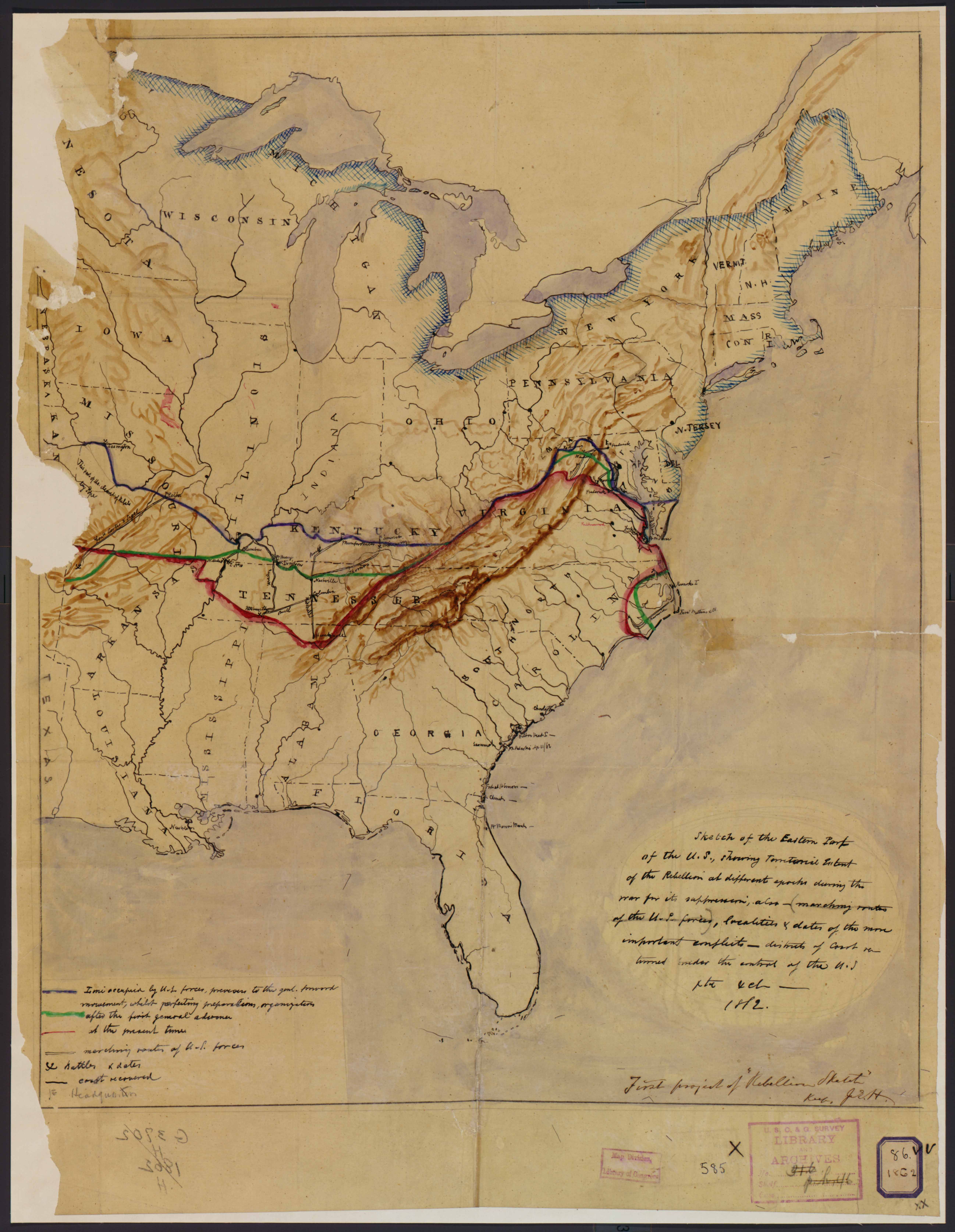
| Title | Sketch of the Rebellion for 1862
|
| Alternate Title | Sketch of the Rebellion for 1862
|
| Creator | Hilgard, J. E. (Julius Erasmus), 1825-1891
|
| Type of Resource | cartographic
|
| Date Created | 1862
|
| Digital Origin | reformatted digital
|
| Topics | Civil war | History
|
| Places | United States
|
| Dates | 1861 | 1862
|
| Subject Genre | Military maps | Statistical maps
|
| Handle | http://hdl.handle.net/10176/codu:57833
|
| Rights Statement | Most maps in the Map Collections materials were either published prior to 1922, produced by the United States government, or both (see catalogue records that accompany each map for information regarding date of publication and source). A few have permission from the copyright holders as noted in the descriptive record. The Library of Congress is providing access to these materials for educational and research purposes and is not aware of any U.S. copyright protection (see Title 17 of the United States Code) or any other restrictions in the Map Collection materials. Note that the written permission of the copyright owners and/or other rights holders (such as publicity and/or privacy rights) is required for distribution, reproduction, or other use of protected items beyond that allowed by fair use or other statutory exemptions. Responsibility for making an independent legal assessment of an item and securing any necessary permissions ultimately rests with persons desiring to use the item.
|
| Language | English
|
| Extent | 1 online resource (map) : JPEG file, col.
|
| Physical Note | Raster | Original Sheet(s): 49 x 40 cm.
|
| Scale | 1:6,000,000
|
| Coordinates | (W 94°--W 70°/N 48°--N 25°)
|
| Notes | » Website description: This is the Coast Survey’s prototype for a map that captured the state of the rebellion in spring 1862. Note the detailed legend in the lower left marking battle sites and troop routes. | » Hand-colored. | » Shows areas occupied by the U.S. forces at several times during the early Civil War using blue, green, and red boundary lines. | » Covers the U.S. westward to approx. 95°W latitude. | » Relief shown by shading. | » Assumed to have been drawn as a preliminary sketch for the printed map "Historical sketch of the rebellion", published by the U.S. Coast Survey in May 1862. | » Pen-and-ink (black and several colors), blue watercolor (for bodies of water), brown watercolor (for relief shading), and lead-pencil additions. | » Classification: G3701.S5 1862 .U5 Classification Scheme: lcc. | » Alternate title from Website.
|
| Local Identifiers | Sketch_of_the_Rebellion.jpg | nationID: 2.04 | nationIDchrono: 3.09 | nationIDcreator: 1.40 | (DLC) 2009584366 | (OCoLC)431797890
|