How maps get used, then reused
In late July I gave a lecture on early maps of what eventually became the Colorado Territory, as part of a conference hosted here at DU on the mapping of the west. I used the following map to illustrate the way that the early Republican Party–which was founded by those opposed to the extension of slavery into the west–used maps to promote their first presidential candidate, the explorer John Fremont. This one, published in New York, used a map from Joseph Colton–perhaps the most successful commercial mapmaker in the United States at that time.
")
A poster from the Republican Party’s first presidential campaign in 1856, protesting the extension of slavery.
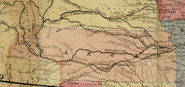
You’ll notice that the map highlights the new Kansas Territory, which was organized by the Kansas-Nebraska Act under the principle of “popular sovereignty,” which meant the potential expansion of slavery. The black lines denote the paths of Fremont in his prior explorations in the west.

The map marks the routes of the party’s candidate–John Fremont–in his treks across the west over the prior fifteen years.
After the talk, Barry Ruderman–one of the nation’s most respected map dealers–brought me a map from his collection that startled us both. It was the exact map in the above broadside, cut out and pasted into a simple brown printed cover. The map had been repurposed, three years after being issued during the 1856 campaign, as a map to the Pikes Peak gold area, in western Kansas (what became Colorado soon thereafter).

Click to open larger image.
On the map, nearly too faint for the naked eye, are lines drawn to direct the overland migrants along different routes to the goldfields of western Kansas. Dozens of guidebooks were produced in 1859 to capitalize on the mad rush of nearly 100,000 men seeking their fortune. But this is truly unique, an example of a “homemade” map that was ripped from its original political intent and repurposed altogether. Notice the lines drawn across Kansas, along the rivers.

Click to open larger image.
Barry Ruderman had held on to the map for over a decade, unable to pinpoint its provenance since it was never actually “published” and remains absent from the fairly definitive lists of gold rush maps compiled by Wes Brown and others. I had been studying the map and broadside since I found it in the collections of the Huntington and the Boston Public Library a few years back. Only when he saw me display the map in its original context were we able to put our heads together to connect the dots and figure out how a political map was reused as a map of the Pikes Peak gold rush.
This is just one example of the great things that happen when map fanatics collide. With special thanks to Wes Brown and Barry Lawrence Ruderman Antique Maps.
Use controls to zoom and pan.